

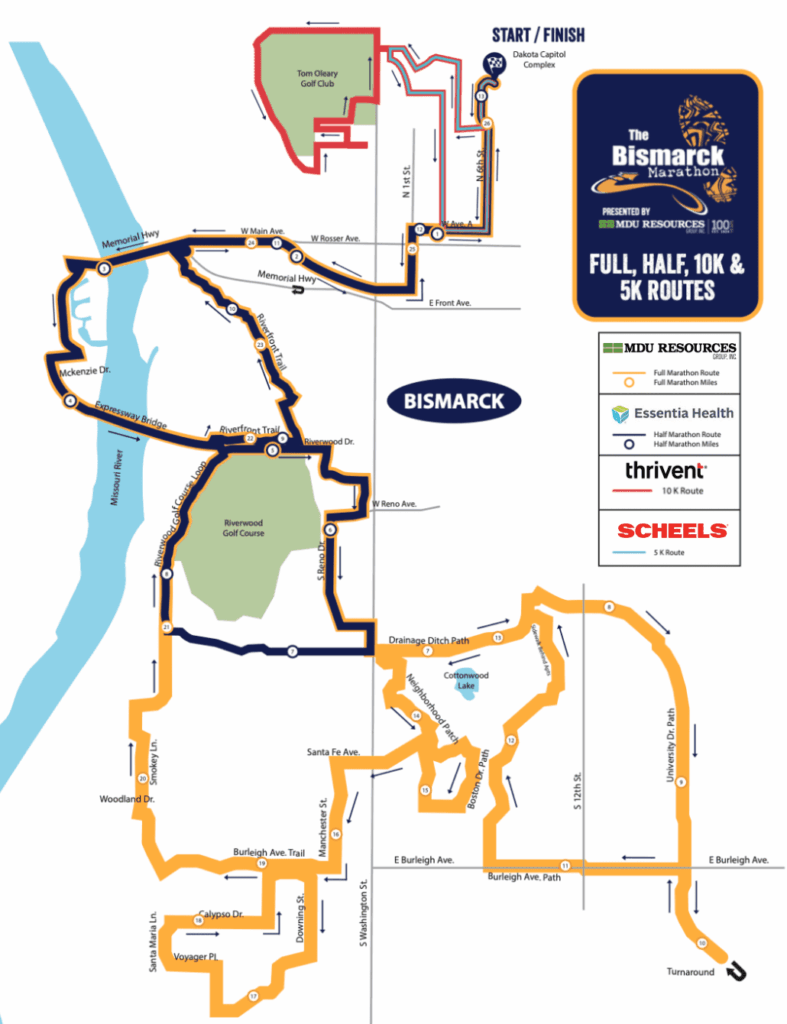
Our Course
Created in 2023 and updated in 2024, the Bismarck Marathon route features breathtaking scenery along the out-and-back course that parallels the Missouri River. Runners are treated to a relatively fast, flat course that promises experienced runners new “personal record” opportunities and novice runners a great race experience. The route incorporates a start and finish line at the North Dakota Capitol Grounds, including new sections that take runners through historic neighborhoods in Bismarck.
The full and half marathon courses are USATF-certified – as well as the 10K, meaning marathoners hoping to qualify for the Boston Marathon may do so here.
Each water station and mile marker along the various courses are sponsored by a local business whose employees compete for fun awards like best dressed, best themed, and most entertaining. These groups help create an enjoyable and entertaining experience for all runners!
Please note: The course enacted in 2023 – and updated in 2024 is not a closed course. The Bismarck Marathon will provide limited traffic control along the course route. Runners hold the responsibility to watch for traffic on open roadways.
Water Station Location Descriptions
● 1: (Marathon mile 1 and 25, half mile 1 and 12) On N 1st St, east side of road, in front
of 409 N 1st St. Open: 7:00 AM. Closing estimate: 1:45 PM.
● 2: (Marathon mile 2.5 and 24, half mile 2.5 and 11) On Main Avenue, south side of
road, on the corner of Lake Ave and W Main Ave, west of Lake Ave. Open: 7:15 AM.
Closing estimate: 1:30 PM.
● 3: (Marathon and half mile 4): On path behind Broken Oar, near break in fence by
parking lot. Open: 7:15 AM. Closing estimate: 8:30 AM.
● 4: (Marathon and half mile 5): On path along Riverwood Drive, just east of the
entrance to Riverwood Golf Course. Open: 7:30 AM. Closing estimate: 8:45 AM.
● 5: (Marathon and half mile 6.5) On Munich Dr, on south side of road, between Reno
and Washington. Open 7:45 AM. Closing estimate: 9:15 AM.
● 6: (Marathon mile 8) On University Dr path, south side of road, just to the east of S
12th St. Open: 7:45 AM. Closing estimate: 9:30 AM.
● 7: (Marathon mile 9.75 and 10.25) On University Dr path, west side of road, at first
turn off south of E Burleigh Ave and south of United Tribes tunnel. Open: 8:00 AM.
Closing estimate: 10:15 AM.
● 8: (Marathon mile 11.5) On Cottonwood path, south of lake, near path intersection of
north and south trails. Open: 8:00 AM. Closing estimate: 10:30 AM.
● 9: (Marathon mile 12.5) On Cottonwood path, just prior to crossing Santa Fe. Access
through the soccer parking lot. Open: 8:15 AM. Closing estimate: 10:30 AM.
● 10: (Marathon mile 13.5) On Marietta Dr, where road travels east-west, south side of
road, mid way down road. Open: 8:15 AM. Closing estimate: 11:00 AM.
● 11: (Marathon mile 15) On Lennox Dr, north side of road, halfway between Peach Tree
Dr and Boston Dr. Open: 8:30 AM. Closing estimate: 11:15 AM.
● 12: (Marathon mile 16) On Burleigh bike path, at intersection with Meridian Dr, west of
Meridian Dr. Open: 8:30 AM. Closing estimate: 11:30 AM.
● 13: (Marathon mile 18) On Santa Maria Ln, east side of road, halfway down road.
Open: 8:45 AM. Closing estimate: Noon.
● 14: (Marathon mile 19.5) On Burleigh path, east of Tavis Rd at entrance to open land
near tornado siren. Open: 9:00 AM. Closing estimate: 12:30 PM.
● 15: (Marathon mile 21, half mile 8) On Riverwood Drive path, just north of entrance to
Nishu Bowmen Club archery range. Open: 7:45 AM. Closing estimate: 12:45 PM.
● 16: (Marathon mile 22, half mile 8.5) On Riverwood Drive path, at maintenance
entrance to Riverwood golf course, just to the south of the W Bismarck Expy tunnel.
Open: 7:45 AM. Closing estimate: 1:00 PM.
● 17: (Marathon mile 23, half mile 10) On Riverfront Trail along Riverside Park Rd, in
front of Sertoma Community Center near Superslide Amusement Park. Open: 8:00
AM. Closing estimate: 1:15 PM.
● 18: (10k mile 2.5) On Ward Road bike path, at entrance to Lady J’s Catering (west
parking lot). Open: 7:30 AM. Closing estimate: 9:00 AM.
● 19: (10k mile 4.3, 5k mile 1.3) On N 1st St, south side of road just east of N Mandan
St. Open: 7:30 AM. Closing estimate: 9:30 AM.
Spiffy Biff Location Descriptions
● S1: (Capitol start / finish area): Quantity 36. 24 of them located near rear
parking lot for DOT, just west of the Sakakawea statue, south side of the road.
11 of them located south of finish line, on capitol loop, on east side of road,
north of library entrance sidewalk. 1 located near start/finish line for race
announcer and timer use.
● S2: (Marathon mile 2.5 and 24, half mile 2.5 and 11) Quantity 5 on Main
Avenue, south side of road, on the corner of Lake Ave and W Main Ave, west of
Lake Ave.
● S3: (Marathon and half mile 5): Quantity 5 on path along Riverwood Drive, just
west of the entrance to Riverwood Golf Course.
● S4: (Marathon mile 7.5 and 13): Quantity 4 on South 3rd St, just south of
Ascension Church and north of drainage ditch, on the west side of 3rd St along
path that travels to the west along the drainage ditch.
● S5: (Marathon mile 11.5) Quantity 4 on Cottonwood path, south of lake, near
path intersection of north/south and east/west trails.
● S6: (Marathon mile 18) Quantity 3 on Santa Maria Ln, west side of road,
halfway down road.
● S7: (Marathon mile 21, half mile 8) Quantity 4 on Riverwood Drive path, just
south of entrance to Nishu Bowmen Club archery range.
● S8: (Marathon mile 23, half mile 10) Quantity 3 on Riverfront Trail along
Riverside Park Rd, in front of Sertoma Community Center near Superslide
Amusement Park.
● S9: (10k mile 4.5, 5k mile 1.5) Quantity 5 on E Arikara Ave, south side of road,
near N 2nd St.
● S10: Quantity 1 located by crosswalk near Expressway tunnel to the west of
Riverwood golf course parking lot entrance for police/volunteer use.